Search
CRATUS LiDAR architecture

Our LiDAR Platform

Sensor-Agnostic.
Edge-Processed.
No Lock-In.

20+ supported LiDAR sensors. Up to 4 sensors fused per edge unit. Solid-state flash LiDAR with integrated camera. Lab-calibrated weight estimation. All processing on the edge.

The CRATUS LiDAR architecture

Any sensor. On the edge. No lock-in.

Most volume measurement systems force you to buy their LiDAR sensor, their software, and their cloud. CRATUS lets you pick the parts that fit your site.

01 / Sensor-agnostic

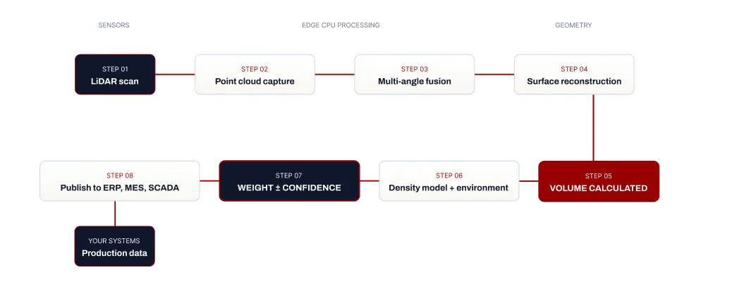
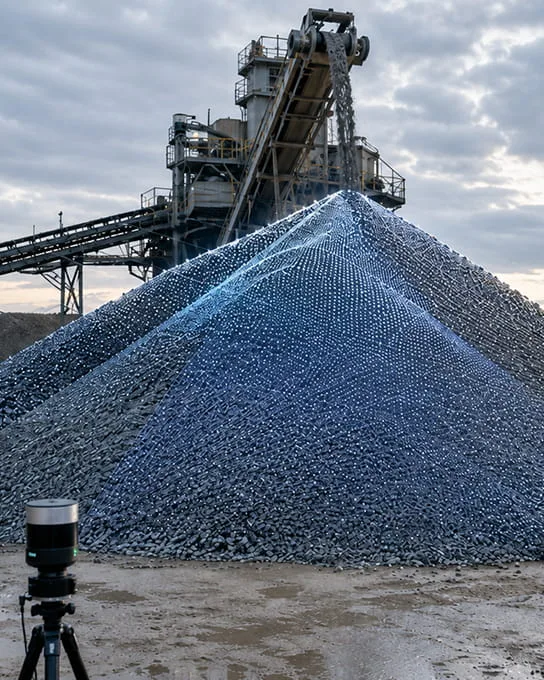
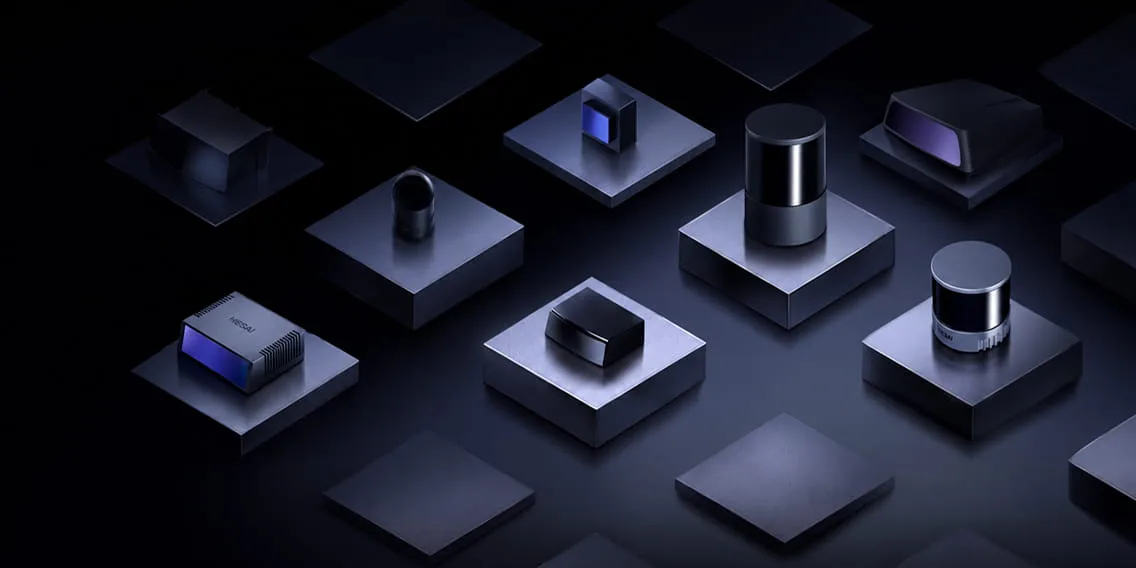
Any LiDAR you need. 20+ models supported.

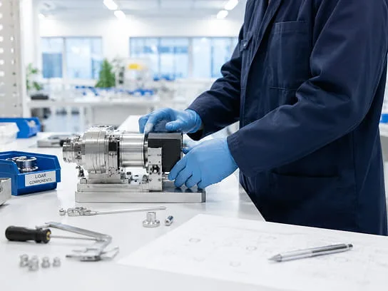
We work with 20+ qualified LiDAR sensors from manufacturers like HESAI, SEYOND, and others. Mechanical spinning, MEMS, solid-state flash, handheld. We match the LiDAR to your range, environment, dust load, lighting, accuracy target, and budget. If a better LiDAR ships next year, swap it in. The CRATUS platform does not care.

02 / Solid-state flash + camera

Flash LiDAR with a camera in the same body

For conveyors and material identification, we deploy solid-state flash LiDAR with an integrated RGB camera in the same enclosure. One field of view, one timestamp, zero parallax. Measure volume and identify color, contamination, and surface characteristics from the same device, in the same frame. No moving parts means no failures in dusty, vibrating environments.

03 / Multi-angle fusion

Up to 4 LiDAR sensors per edge CPU

One CRATUS edge unit fuses data from up to 4 LiDAR sensors at the same time. Scan stockpiles from multiple angles. Cover wide truck lanes with overlapping views. Watch a conveyor from above and the side at once. More angles, fewer blind spots, higher accuracy.

04 / Edge processing

Everything runs on the edge

Point cloud capture, surface reconstruction, volume calculation, weight estimation against your characterized density model, and image analytics all run on a standard CPU at your site. Your LiDAR data stays with you. No mandatory cloud. No punitive per-sensor or per-query fees. Buy the edge CPU outright, or add our cloud platform on a per-node subscription.

05 / Lab-calibrated weight

Weight estimation backed by material science

Volume comes from LiDAR. Weight comes from a density model we characterize in our materials lab and compensate live for humidity, temperature, pile shape, and time. Every weight number ships with a confidence interval.

How CRATUS LiDAR works

From point cloud to weight estimate

The data flow from LiDAR sensors at the site to volume measurements and weight estimates in your systems.

CRATUS LiDAR data flow: LiDAR scan, point cloud capture, multi-angle fusion, surface reconstruction, volume calculated, density model and environment, weight with confidence, publish to ERP, MES, SCADA
Multi-angle LiDAR fusion

More angles = fewer blindspots

Why single-sensor LiDAR systems miss what multi-angle CRATUS fusion catches.

Multi-angle LiDAR scanning of an irregular stockpile with overlapping point clouds

One LiDAR sees half the pile.
Multiple LiDARs see the whole picture.

Real-world stockpiles have undercuts, ridges, and irregular shapes that a single LiDAR sensor cannot fully capture from one mounting point. Single-sensor LiDAR systems treat hidden surfaces as flat, which under-counts or over-counts volume depending on which side is blocked.

CRATUS fuses point clouds from up to four LiDAR sensors mounted at different angles on a single edge CPU. The fused surface model captures the full geometry including the undercuts that single-sensor systems miss. Multi-angle LiDAR fusion is the difference between an approximate measurement and an audit-ready one.

Registration, drift correction, and surface reconstruction all run locally on the edge CPU. No cloud round-trip for the geometry that matters most.

LiDAR sensor compatibility

20+ LiDAR sensors. Four sensor categories.

We qualify and integrate LiDAR sensors across every major category. Selection criteria during the feasibility step: range, field of view, resolution, IP rating, eye safety, dust tolerance, ambient light, and temperature.

CRATUS LiDAR sensor catalog: mechanical spinning, solid-state flash, MEMS, and handheld LiDAR types

Mechanical spinning

360-degree coverage from rotating LiDAR sensors. Long range, high resolution. For wide outdoor coverage areas.

HESAI, SEYOND, others

Solid-state flash

No moving parts. Integrated camera option. Fast capture rates. For conveyors, truck lanes, and harsh environments.

Solid-state partners

MEMS LiDAR

Compact form factor with mechanical micro-mirrors. Cost-effective for fixed-aim applications like silos and bins.

MEMS partners

Handheld LiDAR

Portable LiDAR scanners for on-demand surveys, irregular asset audits, and pre-deployment site characterization.

Handheld partners
CRATUS edge platform

Edge processing for actionable information.
Your LiDAR, your CPU, your data.

The CRATUS edge unit is a compact industrial CPU that processes LiDAR data locally and integrates with your existing systems.

CRATUS edge CPU industrial hardware processing LiDAR data on site

Compact industrial CPU. Wall-mount or rackmount, IP-rated enclosure for plant environments.

Up to 4 LiDAR sensors per unit. Multi-angle fusion runs locally.

Standard protocols. The edge CPU speaks the language your plant already runs on.

REST APIDirect edge query from your services
OPC UAIndustrial automation interop
MQTTLightweight publish / subscribe
MODBUSLegacy PLC integration
SCADADirect historian writes

"On-premise Only" available. No mandatory cloud. No phone-home. Cybersecurity-segmented deployment supported.

Reliability & environmental tolerance

Built to survive extremes.

CRATUS LiDAR systems run in mines, ports, cement plants, and grain terminals. The platform is rated for what those environments throw at it.

ENV

Environmental tolerance

Operating temperature ranges from -40°C to +60°C depending on LiDAR selection. Dust, humidity, vibration, and ambient light all handled through sensor selection during the feasibility step.

SVC

Service and recalibration

LiDAR drift handled through periodic recalibration. Mean time between recalibrations measured in years, not months. One-time engineering fee per service activity, or covered by cloud subscription.

SEC

Cybersecurity posture

On-premises deployment, network segmentation supported, no mandatory phone-home, no inbound internet required. Software update model under customer control.

Engineering & manufacturing

Designed and built in the USA.

CRATUS in-house engineering and materials lab in the USA assembling LiDAR systems
Made in USA

In-house engineering. In-house materials lab.

CRATUS LiDAR systems are designed, integrated, and assembled in the United States. Our engineering team handles sensor qualification, edge unit assembly, integration design, and field commissioning. Our materials lab handles every customer's density characterization.

We sell engineering services as much as we sell hardware. Every CRATUS LiDAR deployment ships with the engineering work that makes the measurement actually work for your site.

The benefits show up in supply chain reliability, faster engineering turnaround, and the ability to customize the LiDAR system for specific industrial requirements without going through an offshore production cycle.

LiDAR technical FAQ

Questions from engineers, integrators, and IT.

Full technical documentation lives in the LiDAR reference manual we share during the engagement.

Which LiDAR sensors does CRATUS support?

CRATUS supports 20+ qualified LiDAR sensors across four categories: mechanical spinning LiDAR, including HESAI, SEYOND, and others; solid-state flash LiDAR, some with integrated cameras; MEMS LiDAR; and handheld LiDAR scanners. We match the LiDAR sensor to your site during the feasibility step based on range, field of view, resolution, IP rating, eye safety class, dust tolerance, ambient light, and ambient temperature.

What is solid-state flash LiDAR and why does CRATUS use it?

Solid-state flash LiDAR illuminates an entire scene with a single laser pulse and reads the returns with a focal plane array, much like a camera. No mechanical scanning means no moving parts to fail in dusty, vibrating industrial environments. CRATUS deploys solid-state flash LiDAR with an integrated RGB camera in the same enclosure for conveyor belt applications, where measuring volume and identifying material color, particle size, and contamination from the same field of view at the same instant matters operationally.

How does multi-angle LiDAR fusion work?

Multi-angle LiDAR fusion combines point clouds from multiple LiDAR sensors mounted at different positions and angles into a single high-fidelity surface model. CRATUS supports up to four LiDAR sensors per edge CPU. The fusion handles spatial registration, drift correction over time, and surface reconstruction. The benefit is full geometry capture on irregular stockpiles, including undercuts and occlusions that single-sensor systems miss.

What is edge processing for LiDAR, and why does it matter?

Edge processing means LiDAR data is processed on a CPU at your site instead of being sent to a vendor cloud. Point cloud capture, multi-angle fusion, surface reconstruction, volume calculation, weight estimation, and image analytics all run on the CRATUS edge unit. Your data stays on your network. The latency is near-zero. Cloud egress and per-query fees do not apply. The edge CPU integrates directly with your SCADA, historian, ERP, MES, or BI tools.

Does the CRATUS LiDAR system support on-premises only deployments?

Yes. The edge CPU operates fully on-premises with no mandatory cloud connectivity. You can query it directly, store data locally, and integrate with your own systems without any traffic leaving your network. The cloud platform is an optional add-on for customers who want multi-site rollup, managed monitoring, software updates, multi-user access, and ongoing support.

What protocols and APIs does the LiDAR edge unit support?

REST API for direct query, OPC UA for industrial automation, MQTT for lightweight publish/subscribe, Modbus for legacy PLC integration, and direct historian writes. Custom integrations are part of the engagement when needed.

How does CRATUS handle LiDAR sensor drift and recalibration?

LiDAR sensors are mechanically and optically stable but drift over time as mounts settle and ambient conditions change. CRATUS handles drift through periodic recalibration scheduled during the engagement. Mean time between recalibrations is measured in years for most LiDAR types, not months. Recalibration is a one-time engineering fee per activity, or covered by the cloud subscription.

What is the cybersecurity model for CRATUS LiDAR systems?

The CRATUS edge unit runs on your network with no mandatory inbound or outbound internet connectivity. Network segmentation is fully supported. No mandatory phone-home. Software updates are pushed under customer control or, if subscribed to the cloud platform, scheduled by us in coordination with your IT team. The platform follows defense-in-depth principles appropriate for OT environments.

Can we run CRATUS LiDAR software on our own server hardware?

The standard deployment uses CRATUS-supplied edge units, which are validated against the LiDAR sensors and tuned for industrial environments. Bring-your-own-hardware configurations are possible for specific customer environments and discussed during the feasibility step.
Talk to LiDAR engineering

Ready for a technical conversation?

Our engineering team is happy to talk LiDAR architecture, sensor selection, edge processing, and integration patterns before you commit to anything.

Interested ?

We would be pleased to send you detailed information about our products or services.
Simply enter your details in the contact form below and we will get in touch with shortly.

CRATUS respects your personal information and keeps it safe. By sending this form, you consent to allow CRATUS to store and process your personal information as stated in our Privacy Policy.

CONTACT US / BUY

One of our experts will be communicating with you shortly. We are committed to understanding your application and providing support, tailored to your specific requirements.