

Safety-Rated Facilities:
Infrastructure-Based Industrial Safety with 3D LiDAR
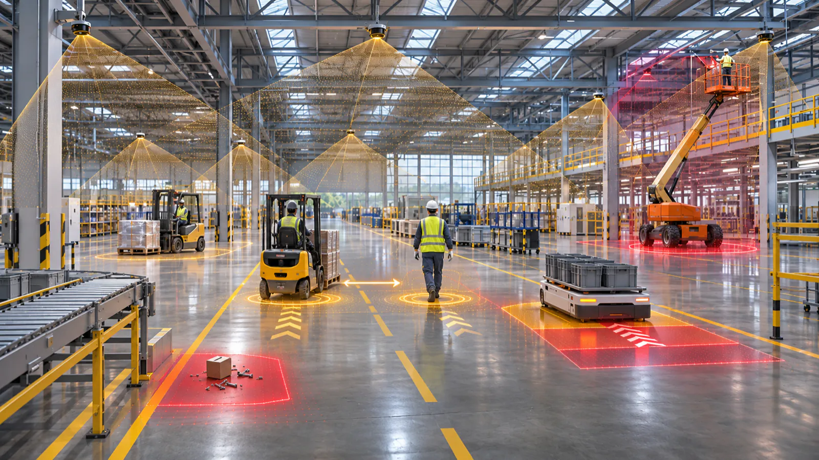
A safety-rated facility is a site where protection comes from safety-rated 3D LiDAR sensors mounted on walls, columns and elevated structures, working alongside the safety functions on each vehicle. Instead of expecting every forklift, manlift, AGV, AMR and scissor lift to carry a complete safety stack of its own, the facility itself watches the shared floor in three dimensions.
Automation is moving fast, but safety often lags behind it. A typical site runs a mixed fleet, and upgrading every machine with its own safety hardware is costly, complex and slow. Even in highly automated areas, unpredictable events such as an object dropping from a load, debris in an aisle or a person stepping out of a blind spot can still endanger workers and stop operations.
Fixed 3D LiDAR adds a layer that no single vehicle can provide: a continuous, high-definition view of people, machines and obstacles across the whole floor. Paired with a real-time locating system (RTLS) for identity and position, the same view also shows operations who and what is where.
Why Vehicle-by-Vehicle Safety Hits a Ceiling
Every vehicle sees the world from its own position. A forklift carrying a tall load cannot see past it, a scissor lift cannot see what is below its platform, and a low-profile AMR cannot see over a pallet. Fitting each machine with extra sensors narrows these gaps one vehicle at a time, but legacy equipment is hard to retrofit, upgrades mean downtime, and a mixed fleet means a different solution for every machine type.
The hazards that matter most are often shared by the whole floor: a crossing where pedestrians meet traffic, a dock door, a working-height zone around a lift. Those are better watched from a fixed position than from a moving one.
How Infrastructure-Based 3D LiDAR Safety Works
- Mount: safety-rated 3D LiDAR sensors on walls and elevated structures cover aisles, crossings, docks and work cells.
- Define zones: warning and protective volumes are shaped around the real hazards of each area, such as a pedestrian crossing, the working height of a lift or an AMR route.
- Decide in the safety controller: the sensor data feeds a safety controller, where the safety logic runs along deterministic paths and triggers a warning, a slow-down or a stop.
- Add context (optional): an RTLS adds identity and position, so a warning can be tied to a specific person, vehicle or asset. It supports visibility and traceability; it is not part of the safety function.
What Infrastructure-Centric Safety Changes
- Human-robot coexistence: as humanoids and autonomous mobile robots begin sharing tight spaces with people, an overhead 3D view lets the facility react before physical proximity becomes dangerous.
- Total floor coverage: fixed-position 3D LiDAR sees what onboard sensors miss: behind loads, around corners, up at the working height of a telescoping lift and down to low-profile AMRs. Covering a large floor takes a network of sensors, planned around the layout.
- Deterministic response: continuous 3D data feeding a safety controller gives predictable warning, slow-down and stop behaviour, rather than relying on onboard sensors alone.
- Lower retrofit burden: protecting the floor can reduce how much onboard safety hardware older vehicles need, and the downtime of fitting it, so existing assets stay in service.
What It Does Not Replace
Infrastructure-based safety is an additional layer, not a shortcut. Every installation starts with a site-specific risk assessment, and some vehicles still need their own onboard safety functions under the standards that apply to them. The goal is to complete the protection the vehicles can offer and, where the risk assessment allows, to reduce what each machine has to carry. Zones, response times and the final safety function are always validated for the site.
The CRATUS Safety-Rated 3D LiDAR
The Safety Airy, the CRATUS safety-rated 3D LiDAR, is designed to PL d (ISO 13849), SIL 2 (IEC 61508) and Type 3 (IEC 61496). It projects a quasi-hemispherical protection zone with separate warning and protective fields, runs two independent dual-processor safety channels and outputs a high-beam-count 3D point cloud from the same unit. That makes it suited to fixed-area guarding, worker-forklift protection and mobile platforms such as AGVs, AMRs and autonomous forklifts.
It is available for pre-order. View the Safety Rated 3D LiDAR or request a quote to discuss your facility.
For the difference between 2D scanners and 3D protection, read 3D Safety-Rated LiDAR vs 2D Safety Scanners. For what makes a LiDAR safety-rated in the first place, see Not All LiDARs Are Created Equal.
Frequently Asked Questions About Safety-Rated Facilities
What is a safety-rated facility?
A safety-rated facility is a site where safety-rated 3D LiDAR sensors mounted on walls and elevated structures monitor the shared floor, so protection does not depend only on the sensors carried by each vehicle. The sensor data feeds a safety controller that triggers warnings, slow-downs or stops.
Can fixed 3D LiDAR replace the safety sensors on forklifts and AMRs?
Not by default. Fixed LiDAR adds a facility-wide layer of protection. Whether it can reduce the onboard safety hardware of a given vehicle is decided by the site risk assessment and the standards that apply to that vehicle.
What can a safety-rated 3D LiDAR detect?
It detects people, vehicles and objects that enter a defined 3D warning or protective volume, including overhanging loads and obstacles at floor level, not only what crosses a single flat scan plane.
What is the role of RTLS in a safety-rated facility?
An RTLS adds identity and position, so operations know which person, vehicle or asset is in a zone and can analyse incidents afterwards. It is a visibility layer; the safety function itself is performed by the safety-rated sensors and the safety controller. See precision RTLS with UWB.
How do we start?
Begin with a risk assessment and a map of traffic and pedestrian routes. From that, define the zones, decide how many sensors the layout needs and validate the safety function with your safety controller. Request a quote and our team can help plan it.

Written by
Founder and CEO, CRATUS Technology, Inc.
Zeki founded CRATUS in 2013 and leads the San Jose team building LiDAR volume measurement systems, IoT sensing platforms, and energy and industrial automation hardware.
Full profileLinkedIn
Interested ?
We would be pleased to send you detailed information about our products or services.
Simply enter your details in the contact form below and we will get in touch with shortly.
CRATUS respects your personal information and keeps it safe. By sending this form, you consent to allow CRATUS to store and process your personal information as stated in our Privacy Policy.