

Ore Stockpile Volume Measurement:
Design Around How Dark the Material Is
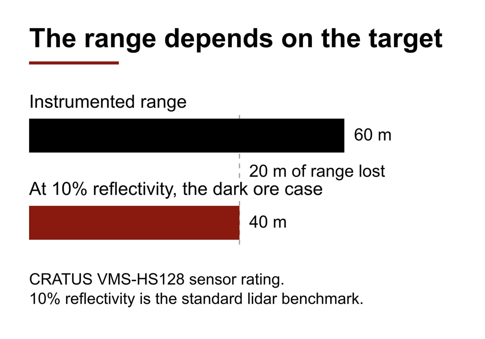
Ore is dark, and dark material sends little of a LiDAR’s light back, so the range on the datasheet is not the range you get on an ore pile. Datasheet range is quoted at a stated reflectivity, usually 10%, and crushed ore, coal and weathered rock sit near that low end. Design stockpile and bin volume measurement around the 10% figure, not the maximum. For the CRATUS VMS-HS128 that means planning around 40 m, not 60 m.
This guide explains why, what gate instruments such as a weighbridge or belt scale cannot tell you, where a volume measurement of the surface helps, and what its limits are.
Why Does Dark Ore Shorten LiDAR Range?
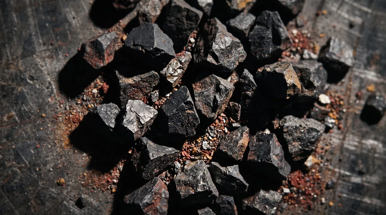
A laser scanner does not measure distance so much as the light that comes back. The darker the surface, the less light returns, and the shorter the distance at which the sensor still gets a reliable reading. That is why range on a spec sheet is always quoted against a target of known reflectivity. The common reference is 10%, a dark and matte surface, and it is the usual benchmark for comparing sensors (see LiDAR technology and architecture for how the sensor and edge compute fit together).
Reflectivity here means reflectivity at the sensor’s near infrared wavelength, which is not the same thing as how dark a pile looks to the eye. Crushed magnetite, coal and weathered waste rock reflect little near infrared light, so they sit at or near the 10% reference, and very dark material can return less. A sensor that behaves well over sand or grain will not automatically behave the same way over ore.
| Target | Range of the VMS-HS128 sensor | What to do with it |
|---|---|---|
| Best case (instrumented range) | 60 m | Do not design against this figure on ore |
| 10% reflectivity (reference target) | 40 m | Design range for dark ore |
| Very dark material such as coal | Below 40 m | Treat 40 m as a ceiling and confirm in the site survey |
We would rather say this up front than explain it six months after commissioning: on an ore site you design against the 40, not the 60.
What Does a Weighbridge or Belt Scale Not Tell You?
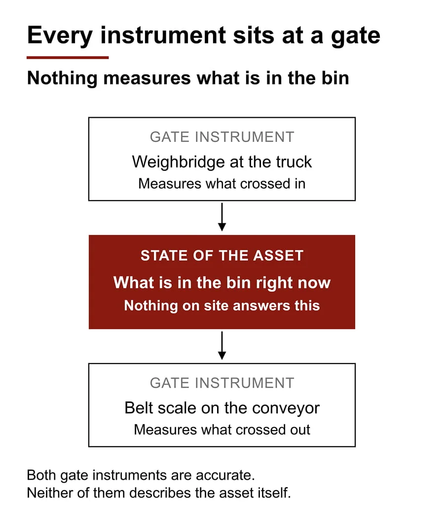
Walk an ore site and count what gets measured. The weighbridge weighs the truck. The belt scale weighs what crosses it. Both are gate instruments: they measure material crossing a boundary, at the moment it crosses, and they do it well. If you are weighing a conveyor load, see our conveyor volume measurement page for how the two approaches compare.
Neither instrument tells you what is sitting in the coarse ore bin, the fine ore bin or on the run-of-mine pad right now. Between the incoming ticket and the outgoing ticket, the contents of the asset are an estimate somebody made, and everything downstream leans on it: mill feed planning, purchasing and the number that goes into month-end close. It drifts a little further from reality every day until somebody climbs the bin to look, or books an adjustment and moves on.
Why Can One Number Not Describe an Ore Bin?
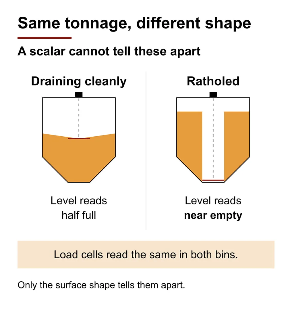
The gap has stayed open because every instrument pointed at it returns a single number: radar, ultrasonic, a plumb bob, load cells under the bin. That is fine for a liquid, where the surface is flat and one number is the volume. An ore pile has a shape, and one number is a poor description of a shape.
In a rathole, ore discharges as a narrow chimney down the middle and leaves the rest stuck to the walls. A level sensor finds the bottom of that chimney and reports near empty while the bin is a third full. Load cells see the tonnage but not the distribution, so a ratholed bin and a cleanly draining bin of the same mass look identical to them. We cover this failure in detail in Accurate Volume Measurement for Silos.
Measure the surface instead and the failure is visible. Volume and peak height come from the same scan, so two values are enough to tell a normal draw down from a bridge or a rathole while the feeder is running:
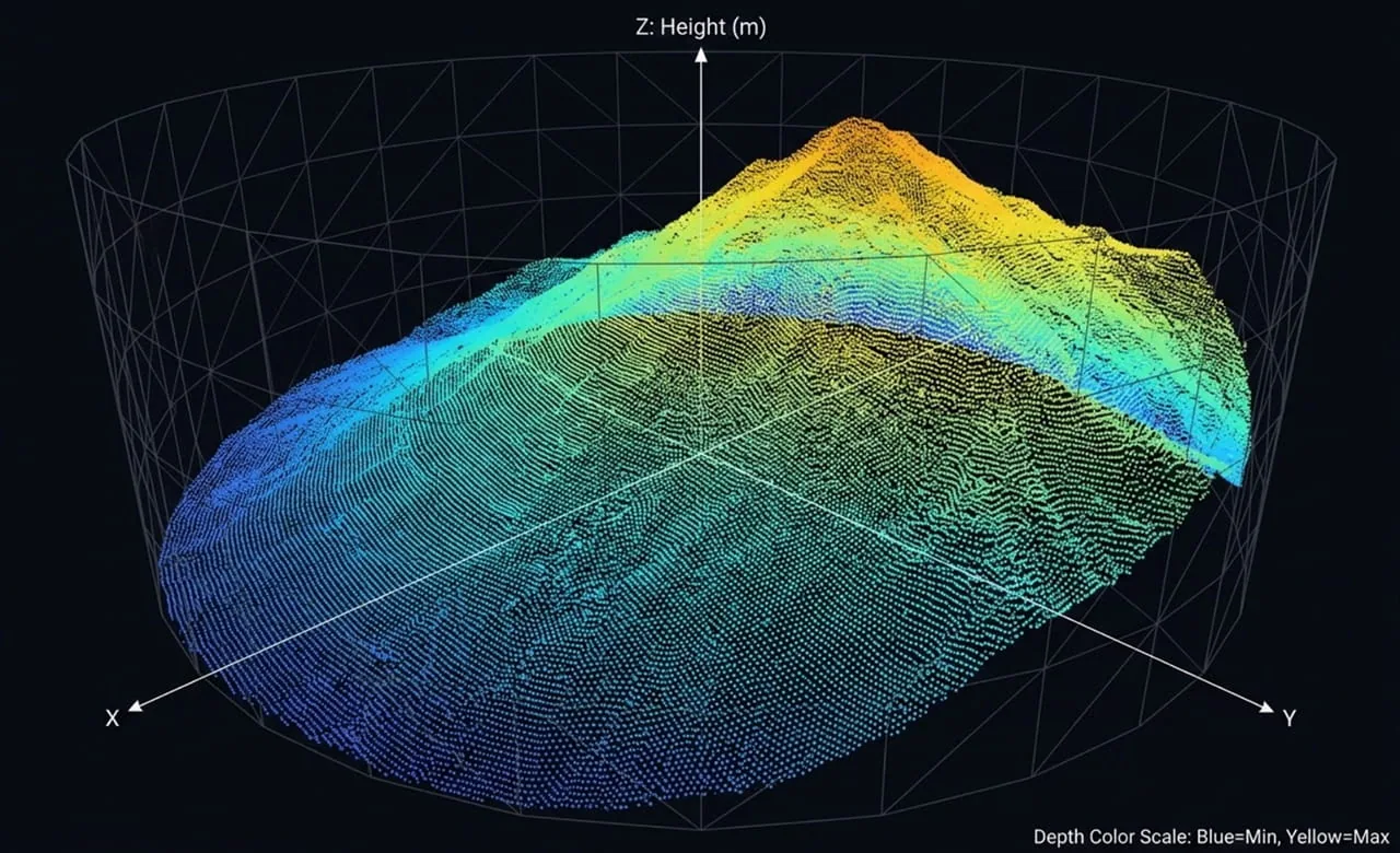
| Volume | Peak height | What it means |
|---|---|---|
| Falling | Falling | Normal draw down |
| Flat | Flat | A bridge is forming over the outlet |
| Stalls high | Holding | Rathole |
Both values can be read in one Modbus TCP read, so the alarm can live in the SCADA you already own. The same pattern is described in The Most Dangerous Job in Your Plant Is Finding Out How Much Is in the Silo.
What Are the Limits of LiDAR Volume Measurement on Ore?
The limits matter more than the features, so here they are.
- Hidden areas. Occluded regions are left out of the estimate rather than interpolated. The system does not invent material it cannot see, which means the reported volume is conservative wherever the sensors’ view is incomplete. Where the sensors go decides how good the number is, so the site survey belongs at the center of the deployment, not at the end of the sales process.
- What the number is for. VMS is an informative instrument for the people who run the plant. It is not a custody instrument and does not replace your weighbridge.
- Change is tighter than the absolute value. Because it is the same sensor, in the same position, looking at the same region of the bin on every scan, the systematic error terms repeat and largely cancel when you subtract one scan from the next. The scan to scan change is therefore a tighter number than the absolute volume, and the change is what production planning consumes. We have not published a figure for that and will not until it is characterized from field data. You can check the reasoning against your own numbers during a pilot.
How Do You Design Around Dark Material?
- Start from the 10% range. Use the reflectivity figure for dark material, not the maximum, and treat very dark ore as lower still.
- Survey the surface before you buy. Every part of the pile or bin surface that matters should be seen by at least one sensor. Areas nobody sees are left out of the volume.
- Decide what the number is for. Planning and reconciliation can use the scan to scan change. Where weight is the legal basis of a sale, keep a certified scale.
- Send two values to the control system. Volume and peak height over Modbus TCP, with an alarm on the combination.
- Reconcile against the weighbridge tickets. Opening volume plus receipts minus dispatches becomes a mass balance, and a deviation becomes a signal instead of noise.
- Run a pilot on your own material. Compare the numbers with yours before you scale up.
What Is It Worth to You?
A permanently mounted scanner over the bin or the pile, scanning on a schedule in dust and darkness and pushing volume and surface height into your SCADA over Modbus TCP, with no process interruption to install it. In practice that means:
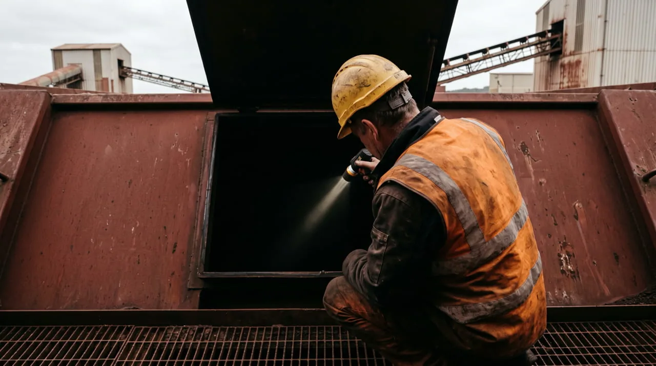
- No more opening hatches to find out what is inside, which takes a permit-required confined space entry (OSHA 29 CFR 1910.146) out of the monthly routine.
- You see a bridge or a rathole while it is forming, instead of finding out when the mill starves.
- A continuous, timestamped state to reconcile the weighbridge tickets against.
- The 40 m figure before the site survey, not the 60 m figure before the purchase order, which is what decides whether any of the above still holds once the system is on the wall.
To size a measurement for your ore, talk to a CRATUS engineer about the VMS-HS128 and see how the system works on the volume and weight estimation page.
Last updated: October 28, 2026. Prepared by the CRATUS engineering team.
Sources
Frequently Asked Questions
Does LiDAR work on black ore or coal?
Yes, with a shorter design range. Dark material returns less light, so the range quoted at 10% reflectivity is the right planning figure, and very dark material such as coal can return less than that. Confirm the usable range in a site survey.
What range should I design for on dark ore?
Design against the range quoted at 10% reflectivity, not the instrumented maximum. For the VMS-HS128 that is 40 m rather than 60 m.
What does 10% reflectivity mean on a LiDAR spec sheet?
It is the reference target used to quote range: a dark, matte surface that returns 10% of the light. Sensors are compared at that figure, so it is a more honest planning number than the maximum range.
Can LiDAR detect a rathole or a bridge in an ore bin?
Yes, because it measures the surface instead of one point. Volume and peak height from the same scan separate normal draw down from a bridge (both flat) and a rathole (volume stalls high while peak height holds). See Accurate Volume Measurement for Silos for the detail.
Does LiDAR volume measurement replace the weighbridge?
No. It is an informative instrument for plant operations, not a custody instrument. It gives a continuous, timestamped state of the bin or pile to reconcile weighbridge tickets against.
How does the volume data reach our SCADA system?
The VMS sends volume and peak height as two values over Modbus TCP, so an integrator can build alarms and trends in the control system you already run, with no new screen for operators to learn.
Measuring inventory across several storage structures? See Bulk Material Inventory Volume and Weight Measurement and the LiDAR volume and weight estimation systems.

Written by
Founder and CEO, CRATUS Technology, Inc.
Zeki founded CRATUS in 2013 and leads the San Jose team building LiDAR volume measurement systems, IoT sensing platforms, and energy and industrial automation hardware.
Full profileLinkedIn
Interested ?
We would be pleased to send you detailed information about our products or services.
Simply enter your details in the contact form below and we will get in touch with shortly.
CRATUS respects your personal information and keeps it safe. By sending this form, you consent to allow CRATUS to store and process your personal information as stated in our Privacy Policy.